
General Thoughts:
The weather in Iceland is incredibly variable, so when you visit, it pays to have flexible plans or flexible travel dates. Even in the summer, storms can flare up with winds exceeding 100 kph, driving rain sideways. Roads can be washed out or closed due to landslides, etc. If you want to hit the back country on the F roads, some of the mountain passes don’t even open until July.
I relied heavily on the information I learned from reading r/VisitingIceland when planning the trip. One of the most common mistakes I saw was an overly aggressive schedule. People were trying to maximize the things they could see in one trip. This is especially true for folks doing the Ring Road, that is, circumnavigating the island. Typically, this is a 10-14 day trip. Sure, you could do that in two brutal days of driving, in good weather. But you won’t see much and will likely end up in a ditch. Route 1 (aka the Ring Road) is not an interstate. It’s not even a good county road by US standards. Except in Reykjavik, it’s a one-lane road with little to no shoulders. It has 210 bridges, a significant portion of which are still one lane (total, not per direction).
So, traffic and weather will be much more significant factors in your travel times than they are in the States. With a prudent selection of places to stop, you can make a fair go of seeing the best things in 10 days. Allowing yourself 14 days adds more stops and/or more time at some locations, and provides some flexibility in case of unforeseen circumstances. After several trips, Jess and I have come to the conclusion that five days is the optimal length of time to be away from home. It’s enough time to see and do interesting things, but gets us heading home about the time we become overstimulated and worrying about the house and dogs.
We can do longer, but it has to be something special, like the Alaska cruise was eleven days away from home. It was beautiful and amazing, but we were ready to be home by the end.
So, using what I learned on Reddit, I plotted four days of activities for a five-day trip with a few optional stops. This avoided me getting stressed out about keeping to a schedule, and left room if we needed to rearrange something. And Day 4 was the overflow day. To maximize its value, I planned to take the first ferry back to the mainland (0900) so we could get on our way. And the first stop was indeed a makeup stop from Day 2, Seljalandsfoss.
This is another one of the iconic Iceland locations where, as a landscape photographer, you get to put your tripod in the holes left by countless preceding photographers and take your shot. I don’t recall exactly why we skipped it on Sunday, but it was our first stop of the day.
Itinerary: (192 km, 3:29 hr.)
- Port of Vestmannaeyjar
- Landeyjahöfn
- Seljalandsfoss
- Selfoss
- Öxarárfoss
- Hotel South Coast (Selfoss)
Route:
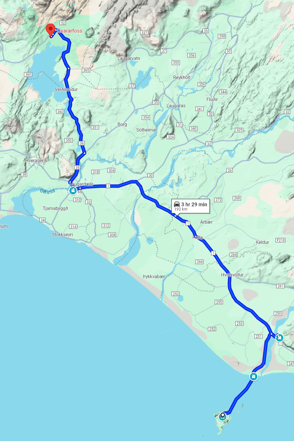
First Leg (via Ferry): Port of Vestmannaeyjar to Landeyjahöfn (15 km, 0:35 hr.)

Before heading to the ferry, we stopped at a coffee shop nearby for some breakfast. The no-frills hotel didn’t even have a soda machine. Then, we drove to the puffin overlook for a few more pictures. It wasn’t quite as cold and wasn’t raining at that moment, so I like today’s shots much better. Then back down to the harbor for the ferry ride back.
The first leg here is the reverse of yesterday, getting back to the mainland. How to line up in the port area was a lot more confusing because of the cramped conditions, but I managed to figure it out in time. We got our return ticket scanned and the car safely packed onboard. Then, back up to the lounge for the ride.
Second Leg : Landeyjahöfn to Seljalandsfoss (15 km, 0:12 hr.)

This was an easy leg. Go back to the Ring Road, turn right, cross the bridge, and turn left. You can’t miss it; it’s a giant waterfall clearly visible from the Ring Road. It was now 1000, and the parking lot was a zoo. There was room for around 150 cars, and we managed to get one of the last spots. So, I knew right away I needed to set my expectations appropriately low in terms of getting a clean shot. and that’s exactly what I needed. There were people everywhere.
As a waterfall, this one is striking with a 90m drop, giving a nice wall of water. However, the flow is relatively low, so it’s not particularly dangerous. Previous erosion has hollowed out a large space behind the fall. You can follow a trail all the way around the drop. According to my photo notes, you can get a pretty interesting shot with a wide-angle lens if you back all the way up in that space. Of course, if I tried that today, all I would get is the back of a bunch of heads, so I don’t even try.
This is a geologically interesting place. There are four falls along this stretch of cliff face, including a neat one that drops into a little hidden space. The trail starts at the main falls and continues approximately 2 km along the cliffs, providing easy access to the other falls. It’s worth the walk because 90% of the people never leave the area around the main falls.
Third Leg: Seljalandsfoss to Selfoss (70 km, 0:54 hr.)
After a while, it was time to get out of that goat rodeo and head East. Because I wasn’t sure what we would be doing on this day, I booked a hotel in Selfoss, which is about halfway between Vik and Reykjavik.
Selfoss is interesting to me personally as one of the name sources I used for my SCA persona. According to the Íslendinga Saga (Sagas of Icelanders) Ingólfur Arnarson wintered on the west bank of the Ölfusá river during the winter of 873-74, under the Ingólfsfjall mountain, the settlement that later became Selfoss.
Geographically, it’s interesting because, unlike many of Iceland’s rivers, the Ölfusá is a mighty one. In addition to the current bridge, built in 1945, the only other crossing is located over 30 km upriver and requires a winding detour. Consequently, this is a major crossroads on the southern coast. I can attest, the bridge is busy.
It’s also the last major town if you are heading east until the eastern end of the south coast. Beyond Selfoss, heading east, you start to encounter single lane bridges and long stretches of absolute nothing.
Since it was approaching lunchtime and breakfast was something light that we grabbed on our way to the ferry, we decided to try a take-out hot dog stand next to the bridge. It’s more substantial than it sounds. Icelanders take their hot dogs fairly seriously, with many varieties to choose from and some very interesting toppings.
Way too early to check into the hotel and we had places to see…
Fourth Leg: Selfoss to Öxarárfoss ( 47 km, 0:43 hr.)

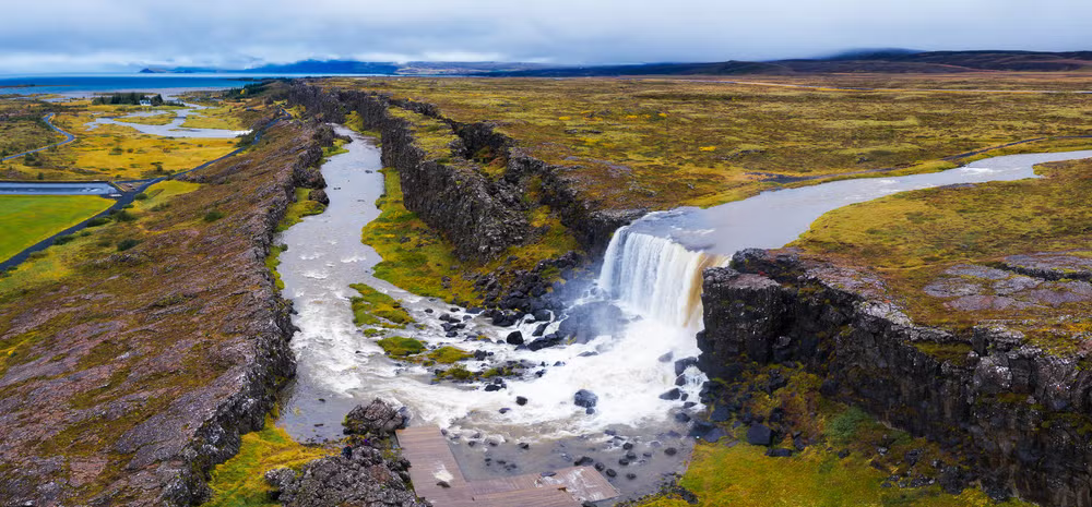
After lunch, we headed north into Þingvellir National Park, a beautiful area featuring a large lake, waterfalls, and interesting geology, as it lies on the rift between the North American and Eurasian plates, which are slowly drifting apart. There’s a place where you can scuba dive a fissure on the plate boundary that’s over 200′ deep. If you fancy maybe getting entombed during the next earthquake, you can join the demented divers who explore it and the surrounding underwater caves. I will pass, thanks.
Þingvellir was also the site of the Alþing, Iceland’s annual parliament, from 930 to 1798, when it relocated to Reykjavík. Since it has been protected land for more than a thousand years, it’s the largest swath of what passes for forest in Iceland. The soil is poor, and the weather is harsh; therefore, the trees that do grow there are more like oversized bushes. Still, compared to the relatively barren landscape that makes up the rest of the island, it’s lush by comparison.
Our first stop in the park was the ranger station/gift shop/convenience store for a restroom break, and we may have gotten a shot glass to add to our collection. From there it was only a couple kilometers to Öxarárfoss.
Parking at attractions in Iceland is almost never free. It could be a gravel lot in the middle of nowhere, like this one in Þingvellir, and it would have a small kiosk for payment. Some of these may accept credit or debit cards, but they primarily encourage you to use their app. There are two or three apps for parking; the main one is Parka. If you plan on driving in Iceland, you should load that one before you leave.
You don’t want to be out in the wilds when trying to download these apps. While your phone may say ‘5G,’ it’s lying. That icon simply indicates that the phone’s 5G radio can detect a 5G tower. The amount of data it can handle depends on the signal strength. At the edges of the coverage area, it will spend more bandwidth on error correction and retries than anything else. That’s fine if all you are doing is completing a transaction. It’s less fine if you are trying to download the app and setup an account.
The fee is usually only a couple of hundred Kr, not a big deal. Mostly, it’s wrestling with the wireless connection and getting the app to connect to the kiosk; sometimes it takes a few minutes of fussing. Jess handled all of these; she has more patience than I do with poorly implemented software.
The parking lot was the usual gravel affair, but it had two designated areas: one for buses and one for cars. There weren’t many cars here, so I had hoped it wouldn’t be very crowded, but there were several buses. As it turns out, a couple of those were collecting up their passengers and getting ready to leave. By the time we hiked up to the waterfall, there were only a half dozen people there.
From the parking area, you had to hike up to a notch and into one of the narrow rift valleys. Inside was a boardwalk that, based on the sign we couldn’t really read, ran 1700m in either direction. From our previous visit, a bus tour, I knew that one end of the boardwalk connected to a long ramp up to the top of the formation where buses stopped for the scenic overlook (and gift shop). Getting up there would be quite a hike and we didn’t feel the need to see that gift shop again.
As it was, the waterfall was 400m to the right and we headed that way. There weren’t many people on the boardwalk, and when we arrived at the waterfall, half a dozen people were admiring it and taking photos. Happily, all of them were the “good” kind of tourist. Someone would amble up to the viewing area, take in the scene, and wait for a turn at the front edge for an unobstructed shot or two, then step back and let the next person get their shot.
No one hogged the primo spot; no words were exchanged. People just did what was right and had a smile and a nod for everyone. Nice. After that, we were good on waterfalls and headed back to the car.
Below is a picture (not mine) of the area that really shows how the land is literally being ripped apart by continental drift. Obviously a drone shot (scraped from the web, there was no credit given).
Fifth Leg: Öxarárfoss to Selfoss (47 km, 0:43 hr.)
Getting out of the park, I decided to ignore the nav system’s suggestion and take a narrow (and in Iceland, that’s really narrow) road along the lake. Along that road were isolated camping and picnicking sites with outstanding views. I imagine you have to rent those; none of them were occupied that day. It’s also the road to access the rift you can dive into, and there was a van load of folks gearing up to do just that.
After 10 or 15km, we hit the end of the road, sort of. The reason the nav system wanted me to stay on the higher road was that this one is blocked off just before it would have rejoined that road at the other end of the lake. Great, glad it was pretty because we had to backtrack and get on the other road to actually leave. It doesn’t sound like a big deal, 30km, but you can’t drive that fast on these roads; they are very narrow, in poor condition, and have very limited sightlines. It took at least half an hour to return to a spot 100m past where we had just been on the lower road. Oh well, we weren’t in a hurry and it was pretty.
We drove back to Selfoss along the swift-flowing Ölfusá river. Back in Selfoss, it was raining again but it was late enough that we could check into the Hotel South Coast. We had noted its location on the way through earlier, so it was easy to find, and it had a nice little parking lot in back. Though that entrance was not friendly to roller bag luggage.
While I struggled with that, Jess got us checked in, yay. This was the final hotel, and throughout the trip, we had no issues with bookings, all of which I had made online three months prior. I don’t recall a trip as smooth as this one before.
The rooms were decorated in the high-end IKEA style we’ve come to expect, and they were also overheated, as we’ve come to expect. Like the hotel in Vik, this one included a breakfast that’s halfway between a continental breakfast and a proper English breakfast. Good enough to start the day.
We had dinner at Kaffi Krús, a short walk away. A nice little place that also did take-away baked goods. There was no way we could try any desserts, meals were already more than we could normally finish. Plus, the bill for a cheeseburger and an order of fish and chips, along with two sodas, came to almost 9,000 Kr (~$70).
Walking back to the hotel, we walked through a pedestrian-only area full of small shops (all closed at this time of day) and pubs, plus an ice cream shop. Well, there was a little room for dessert now, so we stopped in there. It was called Groovís Ice cream & Donuts. The menu was all in Icelandic, but ice cream is not hard to figure out. I got a milkshake anyway, and it came with three small donuts that were made on the spot by this little robotic donut maker. They aren’t going to put Krispy Kreme out of business, but it was cool to watch while we waited.